Hirpur Fm
Type Locality and Naming
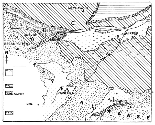
Its name is derived from village Hirpur in the Rembiara valley where the section is thicker, well exposed and better accessible (Bhatt, 1989). Type section is in Rembiara river section (section on left bank of the river), (Bhatt, 1989). Its thickness is 800 m. Though many candidates such as Romushi river section, Shaliganga river section, Suk Nag section, Firozpur nala section, Ningal nala section, Laridor-Malapur section, and Nichahom section are available for the designation of reference section but it has not been done yet. [Original Publication: Bhatt, D.K. 1989. The lithostratigraphy of Karewa Group, Kashmir Valley, India and a critical review of its fossil record. Memoirs Geological Survey of India, 122: 85p.]
Synonyms: Wadia (1941) earlier referred to this sequence as the “Lower Karewa Stage”. Farooqi and Desai (1974) designated this part as the Pakharpura Formation. Since the section at Hirpur is much better developed, Bhatt (1989) designated it as the Hirpur Formation.
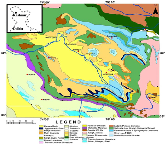
[Figure 1: Geological map of the type area of Hirpur Formation (Bhatt, 1989)]
Lithology and Thickness
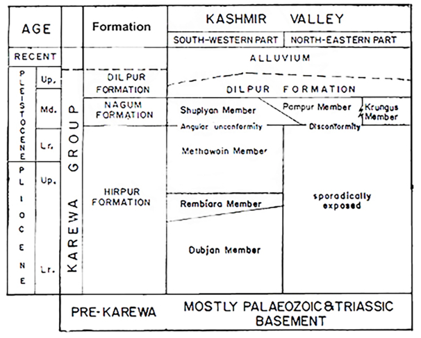
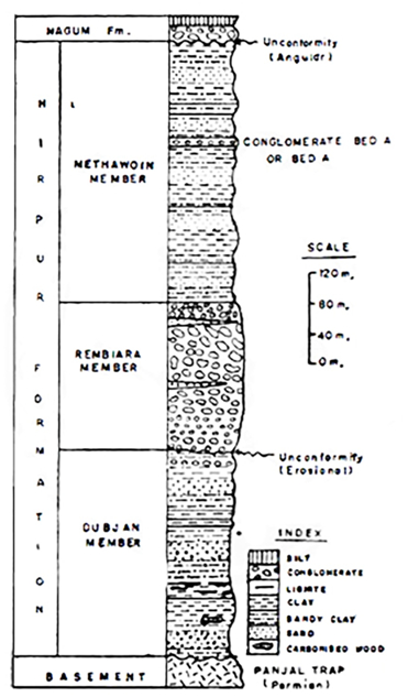
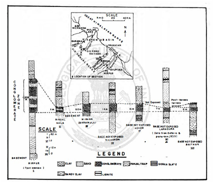
Clay to conglomerate. It is made up of plastic gray to bluish-gray clay, light gray sandy clay, lignite, lignitic clay, medium to coarse-grained sand and conglomerate. 1200 m thick. In most of the sections a conglomerate is developed in the middle part, enabling to divide this formation in three members, viz., the Dubjan, Rembiara and Methawoin (Bhatt, 1989):
Dubjan Member: The lowest member is made up of clay, lignite and sand with sporadic lenticular pebble beds and has a maximum thickness of 600 m. The conglomeratic Rembiara Member overlies it. Fossil insects (Tripathi and Chandra, 1972), mollusks (Bhatia, 1974) and ostracodes are known from the Dubjan Member.
Rembiara Member: This was described by De Terra and Patterson (1939) as “Basal Gravel Fan.” Farooqi and Desai (1974) considered it as the base of the Karewa succession. In the type section the sand dominated part of the Dubjan Member is followed by conglomeratic sequence, which has a sharp and irregular basal contact with the Dubjan Member and abruptly overlain by the Methawoin Member. The Rembiara Member measures between 200-225 m. The conglomerate has subangular to rounded clasts of quartzite (75%), volcanic rock (15%) and other rocks (10%) ranging in size 5 to 30 cm along longer axis. The matrix of the conglomerate varies from medium to coarse grained. The deposition of the Rembiara Member took place on the alluvium fan with prominent braided stream.
Methawoin Member: This upper member is clay, sandy clay, clay, lignite, lignitic mud and a few conglomerate beds. The clasts in conglomerate are subrounded to rounded and range in size from two centimeters to 15 cm. In the Hirpur section lignitic mud and several meter-thick sand bodies are overlain by conglomerate.
[Figure 2: Classification of Karewa Group (Bhatt, 1989)]
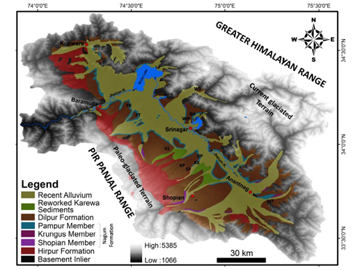
[Figure 3: Spatial distribution of various units of the Karewa Group (after Bhatt, 1989, source Dar and Zeeden, 2020)]
[Figure 4: Lithocolumn of Hirpur Formation in the type area (Bhatt, 1989)]
Relationships and Distribution
Lower contact
Hirpur Formation rests unconformably over the Precambrian to Mesozoic rocks (e.g., local Drumgam Fm or more widespread Wuyan Fm of Jurassic)
Locally, the lower contact is unconformable with the underlying Panjal Volcanics Fm of middle Permian.
Upper contact
Upper contact unconformable (in SW part of basin) to disconformable (in NW part of basin) with overlying Nagum Fm.
GeoJSON
Fossils
Mammals: Hexaprotodon, Cervus sivalensis, C. punjabiensis, Elephas hysudricus, Equus sivalensis, Kilarcola kashmirensis, K. indicus, Kilarcola inidcus sahnii, Indosuncus bhatili, Episoriculus repenningi, Soriculus kashmiriensis, Apodemus dominans debruijni, Rhagapodemus debruijni, Mus jacobsi. Fish: Schizothorax esocinus, Schizothorax sp., Oreinus sp., Cyprinus carpio communis; The Methawoin Member yielded Cervus sivalensis, C. punjabiensis and Equus sivalensis. Molluscs: Bensonia sp., Bithynia tentaculata var kashmirensis, Gyraulus pankongensis, Corbicula sp., Lamellidens sp., Planorbis Planorbis tangitarensis, Menetus cf. M. pearletti, Vallonia pulchella, Vertigo ovate, Cochlicopa lubrica, Succinea indica, Pisidium (Eupisidium) hydaspicola, Pisidium (Eupisidium ?) mitchelli, Lymnaea (Galba) andersoniana forma simulans, L. (Pseudosuccinea) acuminate forma hians, Indoplanorbis exustus, Anisus gulmargensis, Armiger annandalei, Cochlicopa lubrica, Succinea indica. Ostracods: Zonocypris costata, Cypridopsis sp., Ilyocypris bensoni, Eucypris cf. E. moguntiensis, Cypridopsis vidua, Candona candida, C. compressa, C. fabaeformis, C. kashmirensis, C. lactea, C. margengoenssis, C. neglectea, Cyclocypris laevis, Ilyocypris gibba, Darwinula stevensoni, Cytherissa lacustris, Limnocythere franki, charophytes: Nitelolopsis megarensis, Lychnothammus barbatus, Chara globularis, Chara vulgaris. Plants: Pinus sp., Cedrus sp., Abies sp., Ephedra sp., Salix sp., Betula sp., Carpinus sp., Corylus sp., etc. Diatoms: Amphora, Cymbells, Fragillaria, Suriella, etc. (Prashad, 1925; Badam, 1972; Singh 1972, 1977; Bhatia, 1974; Tewari and Kachroo, 1977; Sahni 1982; Sahni and Kotlia 1985; Bhatt, 1989; Kotlia, 1989, 1991, 1990, 1992, 2013; Kotlia and Koenigswald, 1992, Kotlia and Mathur, 1992; Bhatia et al., 1998; Kotlia et al., 1998; Kotlia and Sanwal, 2005).
Age
Depositional setting
Singh (1982) visualized deposition of the Methawoin Member in a shallow lake, major river systems making bird-foot type delta with numerous distributaries extending into the subaqueous part of the lake and depositing bar sands. Along the margin of the lake, mostly a belt of marginal swamp was developed, followed by a wave-effected zone of fine sand and gradually changing into muddy lake bottom. The conglomerates represent deposition by braided streams reflecting phases of lake diminution when rivers extended farther into the lake basin.
Bhatia et al., (1998) described diagnostic chara Nitelolopsis megarensis, Lychnothammus barbatus, Chara globularis and Chara vulgaris. These remains characterize Plio-Pliestocene transition and suggest a depth range of 4 to 12 m for the Karewa lake. Singh (1982) based on sedimentological studies had suggested a depth of 5 to 10 m with a few spots as deep as 30 m.
Additional Information
